Goodridge Corners is a City-led master-planned community in northwest Edmonton, tucked into the corner where Edmonton, St. Albert, and Sturgeon County meet. It’s bounded by the Edmonton/Sturgeon County boundary to the north, the CN Railway (Westlock line) to the west, and Anthony Henday Drive to the south and east. The neighbourhood is designed around three pillars: green, liveable, and affordable.
Development is expected to unfold in stages over roughly 20 years, with the first residential stage (112 ground-oriented lots) already underway.
Sustainability & Access Targets
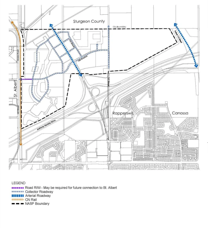
- 100% of homes will be within 500 m of parkland
- 100% of homes will be within 400 m of transit service
- 82% of homes will be within 600 m of commercial service
- At least 10% of all homes will be affordable housing
- Low-Impact Development (LID) storm-water approach using bios-wales and constructed wetlands
Size & Land Area
| Total Gross Area | 259.1–260.1 ha (~640 acres) |
| Gross Developable Area (GDA) | 250.9 ha |
| Adjusted Gross Developable Area (AGDA, after removing institutional/Crown/wetland land) | 183.2 ha |
| Net Residential Area (NRA) | 89.4 ha |
| Parks & Natural Area | ~18.4 ha |
Land ownership: City of Edmonton (~188 ha), Province of Alberta (~67 ha), with a small remainder privately held.
Population & Housing Unit Breakdown
The Plan projects a total population of approximately 9,483 people living in 4,019 dwelling units, for a population density of 106 persons per net residential hectare.
Housing Unit Mix
| Housing Type | Area (ha) | Density (units/ha) | Units | People/Unit | Population | % of Residential Area |
|---|---|---|---|---|---|---|
| Single/Semi-Detached | 35.3 | 25 | 883 | 2.8 | 2,471 | 39.5% |
| Reverse Housing (rear-lane, pedestrian-fronting) | 2.8 | 25 | 70 | 2.8 | 196 | 3.1% |
| Manufactured Housing | 8.1 | 25 | 203 | 2.8 | 567 | 9.1% |
| Town House | 6.8 | 45 | 305 | 2.8 | 853 | 7.6% |
| Street-Oriented Row Housing | 14.8 | 45 | 664 | 2.8 | 1,860 | 16.5% |
| Live/Work Units | 4.3 | 45 | 194 | 2.8 | 542 | 4.8% |
| Medium Density Housing (apartments/stacked row) | 11.0 | 90 | 990 | 1.8 | 1,782 | 12.3% |
| Mixed Use (Residential portion) | 5.4 | 90 | 482 | 1.8 | 868 | 6.0% |
| Town Centre (Residential portion) — mid/high-rise | 1.0 | 225 | 230 | 1.5 | 344 | 1.1% |
| TOTAL | 89.4 | — | 4,019 | — | 9,483 | 100% |
Students / Schools
The Plan projects a total student population of 1,099 students:
| Level | Public | Separate (Catholic) |
|---|---|---|
| Elementary | 366 | 183 |
| Junior High | 183 | 92 |
| Senior High | 183 | 92 |
| Subtotal | 733 | 366 |
The NASP designates Community Services/Institutional land (~8–8.8 ha) that can accommodate future school sites, though specific school locations are determined at later subdivision stages. In the meantime, families in Goodridge Corners have access to schools in nearby established neighbourhoods such as Dunluce, Baturyn, Lorelei, and Castle Downs.
Parks & Recreation
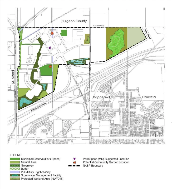
- Urban Village Park (~6 ha) — the main park, intended for sports fields and a possible future Community League facility
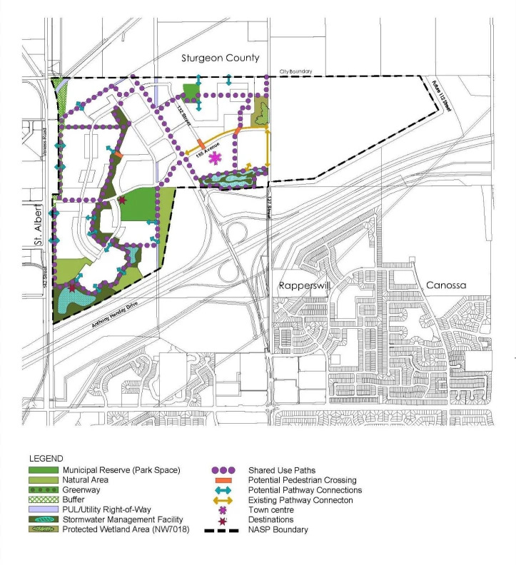
- Greenway — a linear open space corridor for walking/cycling and stormwater drainage
- Two Pocket Parks — one in the north-central area (~1.5 ha) for passive recreation/small gatherings; one in the Town Centre (~0.5 ha) envisioned as an urban plaza for farmers’ markets, festivals, and concerts
- Natural Areas (~10.2 ha) — protected remnant tree stands in the southwest, conserved as municipal reserve
- Community gardens distributed throughout the neighbourhood
- Two storm-water management ponds also function as recreational/visual amenities
Town Centre & Shopping
A ~9.2–10.2 ha Town Centre sits at the heart of the neighbourhood, envisioned as the main destination with:
- Grocery and convenience retail
- Restaurants, cafés, and food & beverage businesses
- Medical offices and retail
- Brewery/distillery, and “flex” light-industrial/R&D space
- 4–6 storey residential buildings integrated into the district (targeted mix: ~90% non-residential / 10% residential)
- A pedestrian-oriented Main Street and Promenade overlooking a storm-water pond
Adjacent to the Town Centre is a Mixed-Use area (~6.7 ha), blending medium-density residential (low/mid-rise apartments up to 8 storeys, stacked row housing) with ground-floor commercial (~80% residential / 20% commercial mix).
Nearby Attractions & Points of Interest

- Anthony Henday Drive – Quick access to Edmonton with the ring road only minutes away!
- Riverlot 56 – St. Albert natural area with walking trails, picnic area and more!
- Servus Credit Union Place – Large Recreation in St. Albert with a gym, hockey arena, pool, indoor soccer, and indoor playground for kids.
- CFB Edmonton (Edmonton Garrison) – approximately 5 km away
- Cattail Crossing Golf and Winter Club – Golf and event venue
- Potential future pedestrian/cyclist/vehicle connection to St. Albert